I. LOCATION
Geographic coordinates: Hanoi is located between 20 ° 53 'to 21 ° 23' north latitude and 105 ° 44 'to 106 ° 02' east longitude, contiguous to Thai Nguyen - Vinh Phuc province in North; Ha Nam - Hoa Binh in the south; Bac Giang - Bac Ninh - Hung Yen in the East and Hoa Binh - Phu Tho in the West.
II. NATURAL AREA
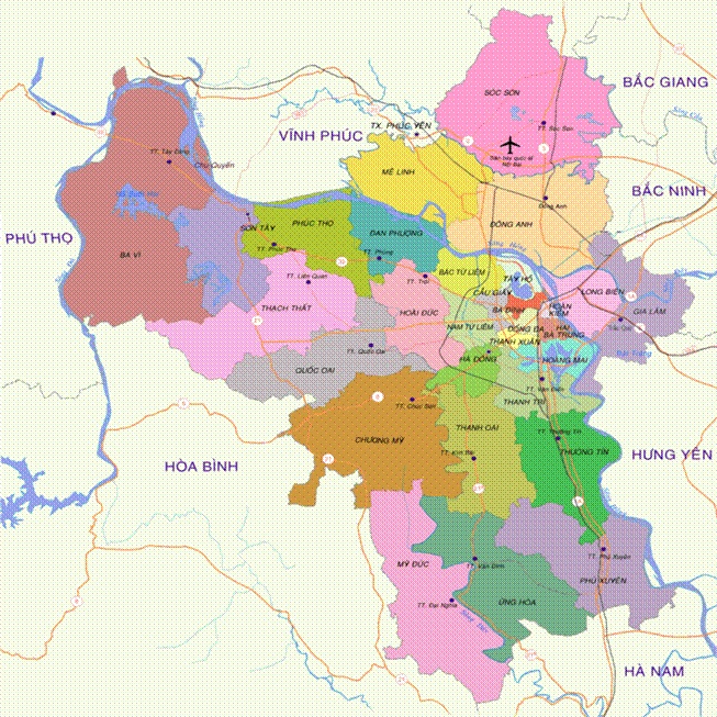
Conclusion of the 6 th plenum of the sixth plenum (Xth session) and the resolution of the ninth session of the XIIth National Assembly at its 3rd session, No. 15/2008 / NQ-QH12 dated 29 May 2008 and this Resolution takes effect. From August 1, 2008, the entire political system of Hanoi city after the unification and expansion of Hanoi's administrative boundaries shall include: Hanoi city, Ha Tay province, Me Linh district, Vinh province Phuc and four communes of Luong Son district - Hoa Binh province. The capital city of Hanoi, after expanding, has a natural area of 334,470.02 ha, which is more than three times larger than before and is in the top 17 capital of the world with the largest area; The population has grown more than 1.5 times, more than 6.2 million, now more than 7 million; including 30 administrative units at district, town, 577 communes, wards and towns.
Hanoi now has mountains, with hills and terrains from north to south, from west to east, in which the plain occupies ¾ the natural area of the city. The average altitude of Hanoi is 5 to 20 meters above sea level, the hills are concentrated in the north and west. The highest peak is Ba Vi with 1,281 meters; Yao 707 meters; Feet of birds 462 meters; Thanh Lanh 427 meters and Thien Thuy 378 meters ... The inner city has some low hills, such as Dong Da mound, Nung mountain.
Area of allocated land (332889.0 ha)
- Agricultural, forestry and fishery land: 188,601.1 ha
- Non-agricultural land: 134947.4 ha
- Unused land: 9340.5 ha
(According to "Hanoi Statistical Yearbook 2010" by Hanoi Statistical Office).
Hydrological:
Hanoi is formed from the Red River delta, characteristic of the geographic area of Hanoi is the "city of rivers and lakes" or "city in the river". Thanks to the large and small rivers have been flowing tens of thousands of years to bring alluvial soil to fill this fertile delta. At present, there are 7 rivers flowing through Hanoi: Red River, Duong River, Da River, Nhue River, Cau River, Day River and Ca Lo River. Of which, the Red River stretches over 163 km (about one third of the river flowing through Vietnam). In the inner city, apart from To Lich and Kim Nguu rivers, lagoon systems are the drainage lines of Hanoi.
In the previous century, there were over 100 large and small lakes, most of which were natural lagoons, traces of dead river lakes leaving some artificial lakes, improving lagoons to lagoon. Currently, although most have been leveled up construction site, so far there are still hundreds of small lagoons are distributed throughout the wards and communes of Hanoi capital. The most famous are the Hoan Kiem Lake, West Lake, Quang Ba, Truc Bach, Thien Quang, Bay Mau, Thanh Nhan, Linh Dam, Yen So, Giang Vo, Dong Mo, Suoi Hai ...
These lakes in Hanoi are not only a large water reservoir but also a natural air conditioning system that makes the metropolitan area less attractive to the heat of radiant heat of concrete, steel, asphalt and activities of the factories ... The lagoon of Hanoi not only creates for the city cool climate - sub-urban climate but also the landscapes, cultural areas of Thang Long - Ha Cabinet.
III. CLIMATE - WEATHER
Located in the monsoon tropics, Hanoi climate is characterized by humid monsoon, hot and rainy in summer, cold and less in winter; It is divided into four distinct seasons: Spring, Summer, Fall, Winter. Spring begins in February (or lunar January) lasts until April. Summer is from May to August, hot but heavy rain. Autumn starts from August to October, cool weather, yellow leaves fall. Winter begins from November to January next year, the weather is cold, dry. The boundaries of the four seasons are only relative, as Hanoi has an early cold, with a late, long, hot year with temperatures of up to 40 ° C, with temperatures falling below 5 ° C .
Hanoi is receiving plenty of solar radiation throughout the year. The average annual radiation is about 120 kcal / cm², the average annual temperature is 24.9 ° C, the average humidity is 80-82%. Average rainfall is over 1700mm / year (about 114 rainy days / year).
In the history of development, Hanoi has repeatedly experienced unusual changes of climate - weather. In May 1926, Hanoi witnessed a terrible wave of sunshine with temperatures of up to 42.8oC. In January 1955, the hottest winter in history, Hanoi lived in a cold price of 2.7 degrees Celsius. And recently, in November 2008, after expanding its administrative boundaries, Hanoi suffered an unprecedented torrent of rain. Almost all streets are submerged in water, with heavy rainfall in excess of all forecasts that have caused a historic flood in Hanoi, causing many to die, causing considerable material damage.
Phuong Anh